The best short hike in the Upper Delaware — three miles, moderate climb, a view of the Big Eddy from above the treeline. The trailhead is a five-minute walk from the Penthouse.
Tusten Mountain Trail is the local hike. It's not a destination hike that anyone is driving up from the city to do — it's the thing you do because you're already in Narrowsburg, you want to stretch your legs, and you want to see the river from somewhere other than the riverbank. It delivers exactly that, and it does it efficiently: about three miles round trip, a real but manageable climb, and one excellent overlook.
The Quick Numbers
- Distance: 2.7 miles round trip (loop)
- Elevation gain: About 700 feet
- Difficulty: Moderate — short but steep in places
- Time: 1.5 to 2.5 hours depending on pace and how long you linger at the overlook
- Dogs: Yes, on leash
- Cost: Free, no permit needed
Getting to the Trailhead
The Tusten Mountain Trail is part of the National Park Service Upper Delaware Scenic and Recreational River system. The trailhead is on State Route 97, about a half-mile north of downtown Narrowsburg.
From the Penthouse: walk or drive north on Main Street, turn right onto Route 97, and watch for the small brown National Park Service sign on the right (river side of the road) maybe a quarter mile up. There's a small parking area — maybe room for six cars. Walking from town takes about 10 minutes; driving takes two.
The trail begins on the river side of Route 97 and almost immediately turns inland and uphill.
The Trail
The Climb (First 0.8 mile)
The trail rises steadily through hardwood forest — oak, maple, beech, birch. There are some short steep pitches and one section of switchbacks. Footing is good but rocky in places; trail runners or light hiking shoes are fine, but flip-flops are a bad idea. You'll cross a small wooden bridge over a seasonal stream around the half-mile mark.
Don't worry about navigation — the trail is well-blazed with yellow markers, and there's really only one path. About 35–45 minutes of steady climbing gets you to the ridge.
The Ridge and the Overlook (Mile 0.8 to 1.3)
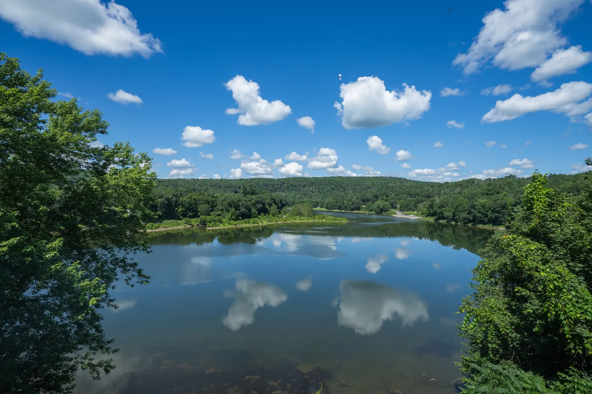
At the top of the climb, the trail levels out along a forested ridge. About a half-mile along the ridge, a short spur trail to the right leads to the Big Eddy Overlook. This is the payoff: a rocky ledge with a clear view down to the Delaware River as it bends through Narrowsburg.
From here you can see the bridge, the deep section of river that gives Narrowsburg its name (the "Big Eddy"), the Pennsylvania side of the valley, and on clear days, far up and down the river corridor. It's especially good in the late afternoon when the western light hits the water, and in October when the foliage in the valley is at peak.
The Descent (Mile 1.3 to 2.7)
From the overlook, you can either turn around and return the way you came (slightly faster, same scenery in reverse) or continue along the ridge to complete the loop. The loop descends through a different stretch of forest and eventually rejoins the original trail near the parking area. The full loop is more interesting; the out-and-back is about 20 minutes shorter.
Best Time of Year
- October: The single best time. Peak fall foliage in the Upper Delaware is mid-October to early November. The view from the overlook into the valley is absurd — fiery reds and golds reflected in the river.
- May: Wildflowers, trillium, and trout lily along the trail. The hardwoods are leafing out, and the trail isn't crowded yet.
- Summer: Hike early. By 10 AM in July it's hot and the climb is sweaty. Mornings are pleasant, and the overlook gets a breeze.
- Winter: The trail is open year-round, and the leafless trees give you views you can't get the rest of the year. Bring traction (microspikes) after snow or freezing rain; the steep sections get icy.
What to Bring
- Water (always)
- A light snack for the overlook
- Layers — the ridge is breezier and cooler than the valley
- Bug spray May through August
- A phone for photos; cell service at the overlook is decent
Trail etiquette: The Upper Delaware corridor is a working landscape managed by the National Park Service. Stay on the marked trail, pack out everything you bring in, don't pick wildflowers, keep dogs leashed (eagles and other wildlife are sensitive). The overlook is a popular spot — if it's busy, take your photos and move along so others can have the view.
After the Hike
You'll be back in town with an appetite. Two minutes' walk from the trailhead parking is the heart of Narrowsburg. Coffee and a pastry at 2 Queens Coffee if it's morning. A beer at Big Eddy Brewing if it's afternoon. Wood-fired pizza at The Laundrette if it's lunch. The whole town is built for the post-hike rhythm.
For more on what to do with the rest of your day in Narrowsburg, see our complete town guide.